US 36 in Western Indiana |
||||
US 36 is an old road, an original 1926 US highway that then began its westward journey in Indianapolis. I saw some really juicy segments of US 36's original alignment on a road trip last fall, and when I found myself with nothing to do on Memorial Day (May 28, 2007) I did a little research and hopped into my car for a day of exploring.
I made it only as far as Rockville on Memorial Day, so on Sunday afternoon, August 19, 2007, I finished the trip. Unlike other roads I've written about so far, I have no real connection to US 36. Until the past year or so, I'd driven it only a few times, for some reason always at night in the rain. Being blinded by oncoming headlights reflecting off wet pavement as I tried to navigate unfamiliar curves in the dark, coupled with the perpetual traffic jam this road is through Avon, left a less than favorable initial impression of US 36. But in the daylight it's not so bad. The road even has some beautiful stretches and pleasant hills and curves, even though it lacks the romance of twisty State Road 62 or the history of US 40. Really, in western Indiana, US 36 is just a way to get from one little town to another. US 36 appears to be an ancestor of an older highway, the 1915 alignment of the Pikes Peak Ocean-to-Ocean Highway, or the PP-OO. This auto trail spanned the coasts like the Lincoln Highway and even had the same endpoints, but took a more southerly route across the country. In western Indiana, the PP-OO went through many of the same towns that US 36 does today (see this map), but its jagged alignment stands in contrast to US 36, which is represented as smooth even in my a 1927 map I have. What makes US 36 interesting to roadfans is that it is rich with segments of old alignments. I think at least one of them may be an old PP-OO alignment, but even if they're not, US 36 was rerouted in several places, leaving behind some winding drives through the country, a segment of road bisected by a man-made lake, a couple miles of a gravel and dirt road, and even two covered bridges along the way. Use the navigation links at the bottom of each page to move from Indianapolis to Rockville along old US 36. |
||||
|
||||
|
Created 26 June 2007. Updated 26 August 2007. |
||||
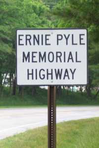 US
36 is named after notable Hoosier Ernie Pyle, perhaps America's most famous
World War II journalist. He died off the coast of Okinawa during the war. But as
a boy, his family lived on a tenant farm about a half-mile north of US 36 in
Dana, which is in Vermillion County on the Illinois border.
US
36 is named after notable Hoosier Ernie Pyle, perhaps America's most famous
World War II journalist. He died off the coast of Okinawa during the war. But as
a boy, his family lived on a tenant farm about a half-mile north of US 36 in
Dana, which is in Vermillion County on the Illinois border.