Southern Indiana Excursion |
|
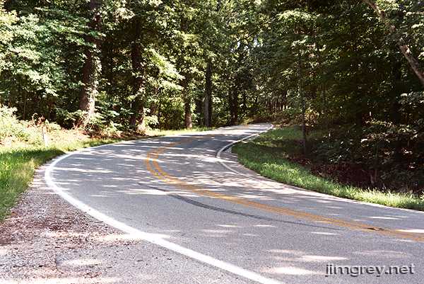
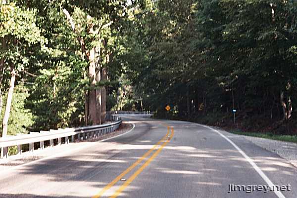
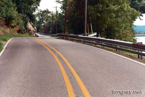
A college friend introduced me to the pleasure of driving old country roads, especially late at night. He and I used to go out after midnight, get some Dunkin' Donuts to fuel the trip, and explore Vigo, Clay, Parke, and Vermillion County roads until we ran low on either gas or sleep. He took me home with him one weekend, to his parents' home in Crawford County. Most of Crawford County is covered with the Harrison-Crawford State Forest and the Hoosier National Forest, and what's left is farmland. He took me out to see "the forestry," as he called it, and we drove some delightful roads cut into the rock as the land sloped toward the Ohio River, dense forest surrounding us. The roads were full of curves and hills, including blind curves at the tops of hills and the bottoms of hollows. He navigated them all confidently, expertly, and at high speed, which regularly took my breath away. He told me he didn't drive as aggressively as he normally did, because he didn't want to frighten me! I vowed to return one day and drive them myself. I kept that vow, but it took me nearly 20 years. Over Labor Day weekend in 2006, I drove south from Indianapolis on a loop that included Crawford County and the state highways my friend showed me there. The route: State Road 135from Indianapolis to Bean Blossom (State Road 45) This road seems so lost in the shuffle in Indianapolis. As you drive south on South Meridian Street, reassurance markers appear somewhere south of Troy Avenue, but otherwise this is just any other Indianapolis artery. After you pass through Greenwood, though, the road takes the character of a country highway, with farmland, the weekend flea market in Trafalgar, and even those odd utility poles where the two beams at the top are at angles that make them appear to meet at one end. The road is straight and flat until you reach Bean Blossom. State Road 45from Bean Blossom to State Road 58 Just as SR 135 looked like it might get interesting at Bean Blossom in Brown County, I came to SR 45. As I researched roads to include on this trip, I found a Web site for bikers that said that SR 45 would "make a man out of you." That was all I needed to hear; it was on my list. I drove its length. It is at its best in Brown and Monroe Counties — a wonderful curvy, hilly road for the 20 miles to Bloomington. Narrow and shoulderless, this road demands your full attention and is a handful in spots. These pictures are taken in Brown County west of Trevlac. This photo points eastbound.
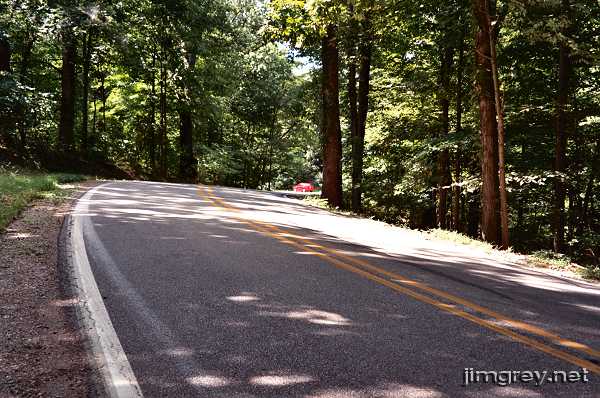
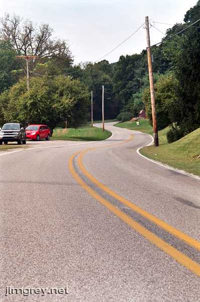
In Brown County, SR 45 passes between the Morgan-Monroe and Yellowwood State Forests, which makes the road seem secluded. Except for some bicyclists and a pickup truck, I had the road to myself. It was warm, and my windows were down. The sunshine broke through the trees and left its patterns on the asphalt. The breeze rustled through the trees and the birds sang. It was just me and my car (and its four-cylinder rattle, which diminished the experience). To take the next photo, I walked up the road a bit and faced westbound. Notice how this curve banks, and how there's nothing between you and the trees should your spirited driving go awry.
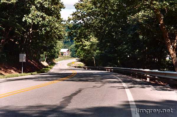
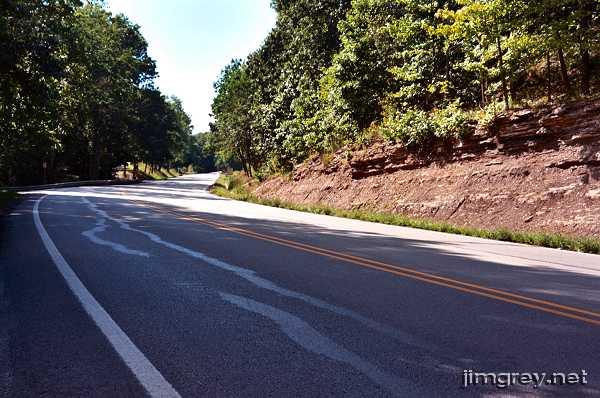
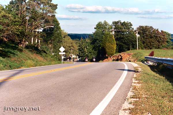
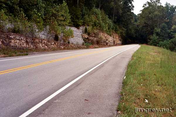
In Monroe County, the woods disappear and civilization slowly returns as country homesteads line the road. The twists and hills remain, however, and are every bit as much fun. But as SR 45 meets Bloomington, the road loses all its charm. It bypasses Bloomington, multiplexed on four-lane divided highways first with SR 46 and then with SR 37. That was such a pain in the butt that I wished I had just gone straight through Bloomington instead. I'll bet that going straight instead of turning right onto SR 46 would have put me on SR 45's original alignment, which probably would have taken me through town and connected with SR 45's current alignment west of SR 37. From Bloomington to SR 58, the road widens, thin shoulders appear, and it meanders with the rolling terrain for about 25 miles. It's a pleasant drive, but it won't quicken your pulse. All pleasure disappears when SR 45 multiplexes with SR 58. The road is straight and flat the last nine miles or so to US 231. US 231from State Road 45 to Loogootee (US 150) I've read that when US 231 came through Indiana, little or no new highway was created for it; instead, a series of existing State Roads were simply re-signed as US 231. The 15 miles of US 231 I drove to Loogootee sure seemed like a minor state highway — it was fairly narrow and had no shoulders. In places it curved broadly and rose and fell gently, but otherwise this road was unremarkable. US 150from Loogootee to Paoli (State Road 37) From Loogootee to about Shoals, US 150 is multiplexed with US 50. It twists nicely in places, and is moderately hilly. Trees alternate with farms for a classic Indiana pastoral scene. The drive is pleasant, especially on a sunny day as my day was. It would make the perfect Sunday drive for two, chatting happily with each other as you glide along the curves. This photo looks eastbound; French Lick and West Baden Springs are about 10 miles east.
I turned around to take this westbound photo. As you can see, this is quite a hill.
After US 50 breaks away northeasterly from US 150 near Shoals, the Sunday drive is over. Wrap up your conversation with your companion, keep your hands on the wheel, and watch the road, because US 150 becomes gloriously twisty and hilly through a lovely wooded area. There aren't many places to pull over on this segment, and so I got only one photo.
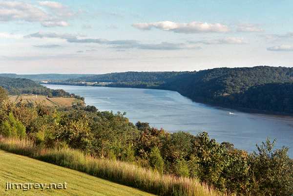
At Prospect, which is just north of French Lick, State Road 56 joined US 150. The woods thinned out and farmland returned for a more open feel. The road was still fairly twisty and hilly and fun to drive the last nine miles to Paoli. State Road 37from Paoli to State Road 62 US 150 and State Roads 37 and 56 converge on Paoli's town square. Rather than intersecting, the three highways multiplex on a single road around the square. It's a big roundabout. You drive counterclockwise around the square, and turn right onto whatever highway you choose. I didn't need to drive the square that day as US 150 enters right where State Road 37 exits. I made my right turn and was on my way south. Even though this segment of State Road 37 cuts through the Hoosier National Forest in Orange and Crawford Counties, it offers ho-hum scenery. Some of it is even scraggly and unattractive. As the hills rise and fall, most curves sweep broadly. A few curves are unexpectedly sharp, which caught me off guard as I lunged for the brakes. State Road 62from State Road 37 to Corydon I had made arrangements to spend the night in Corydon, so I headed east. At the recommendation of a friend, I stopped for an excellent chicken dinner at The Overlook on the western outskirts of Leavenworth. They call it The Overlook because it overlooks the Ohio River. This photo is from a few steps east of the parking lot.
From there I also took a photograph of SR 62 eastbound as it curves and descends into Leavenworth.
My belly comfortably full, I drove on to Corydon. The first-rate curves and hills require full attention, which was tough to give because my system was wigging out over the massive sugar rush brought on by peach pie and ice cream after dinner. State Road 62from Corydon to Evansville (I-164) Next morning, I drove back westward on SR 62, which is very curvy, hilly, and desolate all the way to just past Mariah Hill, some 50 miles away. I normally like to gape at the scenery as I drive and sing along with the radio, but to do either along this glorious road would inevitably have meant braking too late for a curve and finding my car mangled in the rock. I stopped near the entrance to the Harrison-Crawford State Forest, 6 miles west of Corydon, to take a couple photos. The road through here was lovely, thickly wooded and cut deeply into the rock. The morning was chilly, the sky was mostly overcast, and a light mist filled the crisp air. The muted light that spilled through the trees and mist onto the roadway seemed to float ephemerally just above the asphalt.
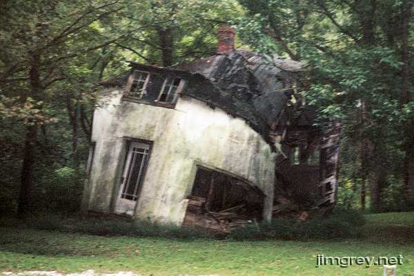
SR 62 offers few places to pull over. I was glad that I could turn around and park in the pulloff area in front of somebody's mailbox here. There were two houses by this pulloff. One was a pretty shaky looking frame house that was either unpainted or painted in that shade of gray that looks like weathered wood. But right next to it was quite a sight: a house that had caved in on itself.
From Dale to Boonville, SR 62's curves broaden and come less often, and the tight, enclosed feel of forest, rock, and guardrails departs for open farmland on either side. After Boonville, SR 62 straightens out entirely. Additional lanes are being laid all the way to Evansville. I-164from State Road 62 to State Road 66 Yawn. Thank goodness I needed only two miles of this road. Next time I make this trip, I'll go only as far as Dale, stop to see the Abraham Lincoln Boyhood Home that's nearby, and take US 231 down to SR 66 for the rest of the loop. State Road 66from Evansville (I-164) to Sulfur (State Road 62) I was excited to see many old alignments of SR 66 exist west of Evansville, all signed "Old SR 66." Some of them looked pretty juicy! I saw one probably abandoned stretch of pavement that had to be Old 66 that couldn't have been two cars wide. I wish I had time to explore and take photos, but I had scheduled too many miles into this morning for it. And what a bore current SR 66 is as it bypasses Newburgh, becomes four empty lanes wide through a secluded industrial area, and cruises up to US 231. There's a neat iron bridge across the Ohio River on US 231, but I couldn't figure out where to park to get a photo of it. As SR 66 hugs the Ohio west of 231 and drew nearer to the Hoosier National Forest, it starts to get more interesting. The familiar twists and rises begin to return as the terrain gets more rugged. This stretch of road is just as exciting as SR 62 from Corydon to Dale, with the extra excitement of hugging the Ohio River without guardrail much of the way. It's, uh, refreshing to round a curve and see only water out the window. This photo of SR 66 eastbound east of Cannelton gives a sense of just how close the water is, even though there happens to be a guardrail here.
The next photo is from the same spot, pointed westbound.
At Rocky Point, the Ohio River turns south as SR 66 goes more or less straight. About five miles later, the river swings back to the north and SR 66 hugs the river again. Up the road a bit, just past Derby, there's nothing between you and a long drink, as this photo shows.
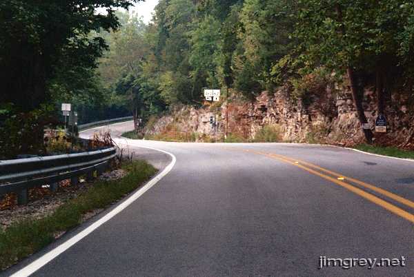
State Road 62from Sulfur to Edwardsville (State Road 64) When SR 66 intersected with SR 62, I turned back toward Corydon. My memory says that this photo is of SR 62 westbound, where it meets and then multiplexes SR 37. (My notes say it's SR 66 "east of Sulfur," but I'm not buying it.) Anyway, this photo shows how heavily wooded this part of the state is, and how deeply some of these roads are cut into the rock.
East of Corydon, SR 62 has a few moments of brilliance but otherwise becomes a fairly standard two-lane state road. At a friend's urging, I stopped for lunch at Polly's Freeze, a last-of-its-breed ice cream stand near Edwardsville, where I had a cheeseburger, fries, and a terrific chocolate malt. State Road 64from Edwardsville to State Road 145 SR 64 begins at an intersection with SR 62 just past Edwardsville. It is kind of neat how it works: From eastbound SR 62, you swing around a curve at this intersection and double back on westbound SR 64. Almost immediately, SR 64 intersects with I-64, which seems like it would be confusing. Beyond I-64, SR 64 becomes a modern, wide, two-lane state highway with sweeping curves and some straightaways. Darn good thing, too, because I was feeling a little loopy after that sugary malt and was glad for a road that didn't demand my best attention. It's prettiest in Crawford County because of the rock and the trees. State Road 145from State Road 64 to French Lick (State Road 56) I picked up SR 145 just outside the Hoosier National Forest in Perry County. I hoped this road would be more interesting than it was, given that it goes through some of the Hoosier National Forest, but it was a pretty boring straight, wide two-lane. It was being widened to four lanes much of the way to Patoka Lake. Traffic around Patoka Lake was fairly heavy with trucks towing boats. State Road 56from French Lick to to State Road 39 SR 145 enters French Lick and ends at SR 56, which is under heavy construction there. Hoosiers seem to like French Lick as a weekend getaway spot, but after waiting there for twenty minutes trying to get through one light I say wait until they finish road construction. Past French Lick, the road is typical narrow two-lane through the equally touristesque West Baden Springs up to Prospect, where SR 56 merges with US 150 for nine miles until Paoli. This stretch was just as much fun this time as it was when I drove it the day before. At Paoli, I drove the southern portion of the town-square roundabout and kept heading east on SR 56. The road is pleasant with broad curves and some long rises through Hoosier farmland. The road is wide, but has no shoulder in many places. After about five miles, the curves end and the hills begin to roll. It's a pleasant drive. At the intersection with SR 337 in Livonia, a sign explained that SR 56 had been coated with gravel and oil for the next several miles. I had never seen anything like it, and I puzzled over it. The sign recommended detouring on SR 337, which I tried for a few miles until I realized it took me away from where I was going. I doubled back and braved the gravel and oil. The speed limit was posted at 40 miles per hour, but I started at 35, not sure what to expect from this driving surface. Cars began to accumulate behind me, so I edged it up to 45. I wanted to stop to take a photo of the road in this condition, but I was nervous about slowing down to pull over on this surface, especially since I was being tailgated. At Salem, the gravel and oil ended, and the road became extremely boring — flat, straight, and wide with full shoulders. Except for oncoming traffic, it felt like I was driving on an Interstate. I was behind schedule and so chose not to explore some curving side roads marked "Old SR 56." State Road 39from State Road 56 to to SR 250 Woo hoo! SR 39 is narrow along its 14 miles with mild to moderate twists and a few really sharp curves, including several 90-degree turns where the road flowed in line with county roads. It's clear that SR 39 was cut from farm roads. A one-foot-wide gravel shoulder provided the only margin for error along SR 39 because beyond the shoulder there was a deep drainage ditch. If I had failed to make a curve, the bottom of my little car would surely have scraped bottom as I slid off the road. I would have loved to take photographs at many places along this excellent road, but there were no places to pull off. In hindsight, I probably could have just stopped in the road, because I never encountered another car. It was just me and the seat of my pants cruising this forgotten gem. This little section of SR 39 is 50 miles or so away from its other section, which begins in Martinsville and ends way up at the Michigan state line. The portions I've driven of daddy 39 are pretty straight and unremarkable. State Road 250from State Road 39 to State Road 135 State Road 250 may merge with SR 39, but curves to align with SR 39. I wonder why the three-digit road number took precedence here. At SR 250, SR 39's twisty characteristics began to fade. State Road 135from State Road 250 to Indianapolis SR 250 flowed directly into SR 135, which is multiplexed with US 50 for three miles here. As SR 135 edged into Brown County and the northernmost portion of the Hoosier National Forest, motorcycles were everywhere as it's a popular biker destination. And no wonder — the late-afternoon sunshine spilled richly through the trees' branches as the road dipped and swung and climbed for about 13 miles to the tiny town of Story. It made me wish I had a motorcycle. Boxed in by motorcycles with few places to pull over, again I could not take photographs of this lovely and challenging stretch of road. I'll have to plan differently next time. Beyond Story, the curves and hills become less intense, but the drive no less lovely, until SR 135 intersects with SR 46 near Nashville. It multiplexes with SR 46 for a few miles and then heads north again as it goes through Nashville. North of Nashville to Bean Blossom, SR 135 curves a little bit here and there, but north of Bean Blossom it's just a simple country two-lane highway all the way to Greenwood, and then a city-grade highway into Indianapolis; the same stretch of highway on which I began my trip. After making this trip, I learned that the first people to settle Indiana did so just north of the Ohio River among the very hills I drove that weekend. These people included young Abraham Lincoln and his family. What difficult country to tame! |
Created 10 November 2006. Last update 6 March 2008. |