The National Road in Ohio |
||||
Clark CountyBy the time I reached Clark County, I was clearly on the tail end of my three-day journey across Ohio’s National Road. After all, Springfield is about three-quarters of the way across the state from east to west. While speed is never my goal on any road trip, I was making very good time simply because US 40 is so straight across most of western Ohio – with only a couple exceptions, it was built directly on top of the National Road from Columbus to the Indiana state line. There was little to see in terms of old alignments and there were no old stone bridges to photograph. So I settled in and just enjoyed the driving. Amusingly, when the road reaches itty bitty Brighton, the westbound lanes go through town while the eastbound lanes bypass it.
Imagery © 2012 Digital Globe, GeoEye, State of Ohio/OSIP, U.S. Geological Survey, USDA Farm Service Agency. Map data © 2012 Google. But US 40 entirely bypasses slightly larger South Vienna.
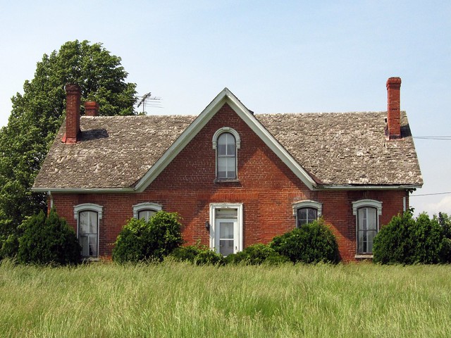
Imagery © 2012 Digital Globe, GeoEye, State of Ohio/OSIP, U.S. Geological Survey, USDA Farm Service Agency. Map data © 2012 Google. This old house, which looks abandoned, stands on the road on the west end of town.
Soon I reached Springfield.
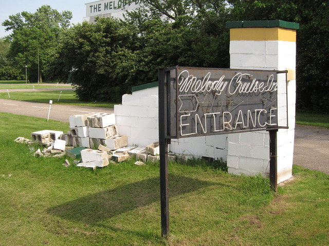
Imagery © 2012 Digital Globe, GeoEye, State of Ohio/OSIP, U.S. Geological Survey, USDA Farm Service Agency. Map data © 2012 Google. I did stop frequently in Springfield because there was so much to see there. This drive-in theater stands on Springfield’s eastern edge. The theater still operates.
The entrance has seen better days.
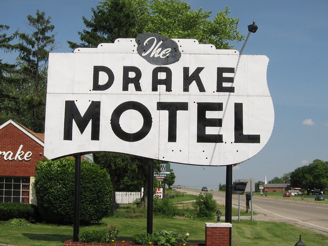
The Drake Motel sign is a National Road landmark. Many of the photos I’ve seen of it (such as this one) showed it in some disrepair, its neon broken and its panels stained with rust. It appears to have been freshly repaired and repainted, but unfortunately its neon was removed. There used to be an almost identical Drake Motel sign (and accompanying motel) on US 40 in eastern Indianapolis, but it was torn down years ago.
Here's the sign in perspective with the motel itself.
US 40 enters and exits Springfield along the Main Street corridor, but through most of town US 40 is routed onto two one-way streets to the north of Main. The Main Street alignment is highlighted in blue on the map below.
Imagery © 2012 Digital Globe, GeoEye, State of Ohio/OSIP, U.S. Geological Survey, USDA Farm Service Agency. Map data © 2012 Google. There’s lots to like about the Schuler’s Bakery building, a few blocks west of where US 40 diverges from the National Road.
Props to them for keeping their neon lit during the day!
The neon is missing from the Tuttle Bros. Auto Supplies sign a couple blocks down the road.
This business seems to be missing from the building, too.
There’s lots of great old signage in and on this building, which once housed Northside Appliances.
This building was once the Shawnee Hotel, but I don’t know how it’s being used today. It sure is striking, though.
This is the Bushnell Building, which was built in 1893. Its claim to fame is that patent attorney Harry Toulmin had his office here when he wrote the patent for the Wright Brothers’ invention of the airplane.
Across from the Bushnell Building is Springfield’s Fountain Square, where this statue of Toulmin looks at the entrance to his former office.
And with that, I rejoined US 40 on Springfield’s west end and and headed out of town. It is said that federal funds for building Ohio's National Road ran out here. Indeed, the major road out of town here is State Route 4. To stay on US 40 and the National Road means taking a dogleg exit.
Imagery © 2012 Digital Globe, GeoEye, State of Ohio/OSIP, U.S. Geological Survey, USDA Farm Service Agency. Map data © 2012 Google. I forgot to look for two things in Springfield. The first is Springfield’s Madonna of the Trail, which is a statue placed here and in 11 other locations along the National Old Trails Road in 1928 and 1929. The National Old Trails Road was a coast-to-coast road that mostly followed the National Road across its six states. The second is the beginning of the Dayton Cutoff, a road that crafty officials in Dayton built to siphon National Road traffic through their town. It worked, too. I guess I’ll just have to go back to Springfield another day! |
||||
|
||||
|
Created 4 February 2012. |
||||