The National Road in Illinois |
|
Remembering the excitement of discovery from our 2006 tour of US 40 and the National Road in Indiana, my friend Dawn and I decided to see more of the National Road in 2007. An old friend of mine from Terre Haute who used to work in Marshall, Illinois, said that he passed some old brick sections of road on his way to work every day and that he thought they used to be US 40. So Dawn and I decided to explore.
The final segment of the National Road was built in Illinois from the Indiana state line west to Vandalia, then the state's capitol. Surveyed in 1828 and built by 1834 or 1838 depending on who you ask, this was probably the poorest segment of the National Road. Accounts that mention the road during these years, such as one written by J. Gould, suggest that in the east the road was mostly macadam, the best road surface available then. Gould said that as the road stretched west, more and more patches of plank-covered or dirt road appeared. By the time the road reached Indiana, macadam sections were few and far between. The last macadam section on the National Road was in Terre Haute; west of there, it was all dirt. In wet weather, dirt roads would turn into mudholes and sometimes be washed out, making them impassable. Tree stumps were frequently left in, cut off just low enough that wagon axles could clear them.
As railroads rose to prominence in the 1800s, the National Road became less important and was not maintained very well. In 1894, Thomas Searight wrote a book about the National Road in which he reported that this road, "grand and imposing" at its beginning, became so insignificant west of the Illinois state line that it simply disappeared into the prairie. Railroads had rendered the road needless. The National Road was reborn in the early 20th century as people bought cars and wanted to drive them places. Period automobile route guides bear this out. The 1916 Touring Information Bureau guide saying that while some sections of the National Road near Illinois cities were of "poor rock," the road was still mostly dirt and was "bad in wet weather." It urged the motorist to "make careful local inquiry regarding conditions," a common warning for dirt roads. The map at left is from this guide. It shows that the route was a little jagged just west of Marshall and that the road hugged, and occasionally crossed, the railroad. The railroad is still there. Demand for better roads grew as the automobile became important in the teens and 20s. Brick was laid and cement was poured starting in 1920 to create a narrow but all-weather National Road. Just as these improvements were finished in 1926, the road was named US 40 and made part of the national highway system. It looks like the road was later widened along the way by adding cement strips on either side. Highways everywhere saw improvements during these years, but surfaces could vary along a road. Motorists were smart to still be concerned with road surfaces and kept turning to road guides for information. The 1925 Mohawk-Hobbs guide to the road spelled out the road's condition mile by mile, and pronounced it consistently good.
Dawn and I set our Illinois trip for the luckiest day, 7-7-07. We set out early that day so we would be sure to get the whole 100 miles in. It's a good thing, too. We were amazed by the amount of brick and cement National Road that remain until about Effingham, most of it easily visible from US 40. We stopped frequently to look and snap photos, which took a lot of time. We averaged 12 miles per hour on the trip! To follow our tour, use the navigation links below. The easiest way to follow along is to click the Next button at the bottom right of each page. |
|
|
Created 22 July 2007. |
|
 But first, a bit of a history lesson from the best of my understanding.
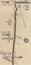 This,
then, was the state of the National Road in Illinois. Still, towns were built along the road in hopes of
a great prosperity, which never quite materialized. Some of these small towns did well enough to remain
vital today, while others have long been in decay. The National Road remains their main
streets.
This,
then, was the state of the National Road in Illinois. Still, towns were built along the road in hopes of
a great prosperity, which never quite materialized. Some of these small towns did well enough to remain
vital today, while others have long been in decay. The National Road remains their main
streets.
 Between 1950 and 1955, many sections of US 40 in Illinois were redesigned to
be a four-lane freeway, bypassing most towns along the route. The first two
lanes were built, but the other two were not. The new US 40 paralleled the
now-abandoned National Road by a matter of feet or yards in many places. Miles and miles of
narrow brick and cement National Road remain in Illinois, and they are a
treasure.
Between 1950 and 1955, many sections of US 40 in Illinois were redesigned to
be a four-lane freeway, bypassing most towns along the route. The first two
lanes were built, but the other two were not. The new US 40 paralleled the
now-abandoned National Road by a matter of feet or yards in many places. Miles and miles of
narrow brick and cement National Road remain in Illinois, and they are a
treasure.